Tag: canada

  • A Prairie Welcome: Maskinonge Overlook and the Gateway to Waterton Lakes

    The vast prairie greeted us as we crossed into Canada, leading us toward the towering peaks of Waterton Lakes National Park. Captured at Maskinonge Overlook with a Canon R5 at 16mm | 1/500s | f/8.0 | ISO 100.

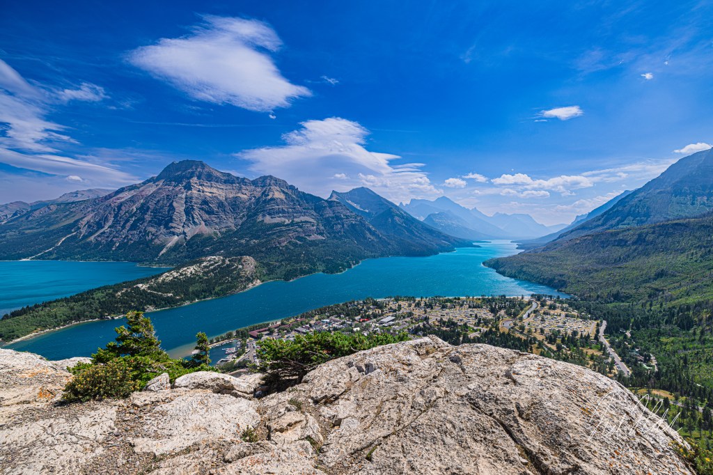
    The Moment of Arrival

    Crossing into Canada, the landscape stretched wide before us—an expanse of golden prairie rolling toward distant mountains. At Maskinonge Overlook, just inside the entrance to Waterton Lakes National Park, we found ourselves in a transition zone where the open plains yield to the rugged peaks of the Rockies.

    The view here is one of contrast and anticipation. Behind us, the Montana plains; ahead, the rising walls of Waterton’s dramatic landscape. The sky moved swiftly, with restless clouds casting shifting shadows across the grasslands and the calm waters of Maskinonge Lake in the distance.

    With my Canon R5 and RF 15-35mm lens, set to auto, I captured the sense of space and depth that defines this place—a land that feels boundless, yet holds the promise of something towering just beyond the horizon. This photo shows the true colors of nature as minimal post processing was performed here.

    Maskinonge Overlook: Where Prairie Meets Peaks

    This overlook, situated near the park’s entrance, offers a glimpse into one of North America’s rarest landscapes. Waterton is one of the few places where the Great Plains and the Rocky Mountains collide so abruptly, creating a rich ecosystem where prairie grasses, wetlands, and alpine forests exist side by side (Parks Canada, 2023).

    The Maskinonge Wetlands, visible in the middle ground of my image, form a vital habitat for migratory birds. This shallow lake and marshy lowlands attract trumpeter swans, pelicans, and bald eagles, making it one of the best birdwatching spots in the park (Nature Conservancy Canada, 2022). The wetlands also serve as a natural filter, feeding the park’s many waterways while supporting an intricate network of plant and animal life.

    For centuries, the Maskinonge area was a seasonal gathering place for Indigenous peoples, particularly the Blackfoot Confederacy (Niitsitapi), who relied on these fertile lands for hunting, fishing, and ceremonial practices (Blackfoot Confederacy, 2021). The name “Maskinonge” itself comes from the Cree word for muskellunge, a type of large fish found in the region’s waters.

    Today, this overlook remains a place of quiet reflection, a moment of stillness before the grandeur of the mountains takes center stage.

    A Landscape Steeped in History

    Before Waterton Lakes became a national park in 1897, this land was part of a vast, untamed frontier. Indigenous communities, fur traders, and early explorers all passed through these prairies, leaving behind a history that lingers in the wind.

    In 1858, British surveyor John Palliser crossed through this very region during his exploration of the Canadian West. He noted how suddenly the land changed—how the “sea of grass” gave way to towering peaks with almost no warning. His observations would later help shape the boundaries of Waterton Lakes, ensuring that this meeting of prairie and mountains was preserved (Geological Survey of Canada, 2021).

    Chief White Calf of the Blackfoot Nation also recognized the importance of this land. In 1895, he negotiated its transfer to the Canadian government, paving the way for the establishment of Waterton Lakes National Park, though the Blackfoot people’s deep connection to the region remains to this day (Parks Canada, 2023).

    The Road to the Peaks

    From Maskinonge Overlook, the Rocky Mountains rise slowly into view, like a promise unfolding from the prairie. This transition—from wide open grasslands to sheer alpine cliffs—is what makes Waterton so distinct.

    As we left the overlook and continued into the park, the landscape seemed to shift with each passing mile. The wetlands faded into the background, replaced by ridges, valleys, and dense stands of aspen and pine. It was as if we had crossed into another world entirely.

    But the prairie, with its golden grasses and expansive skies, left its mark. Before the peaks take your breath away, the land here teaches you to pause, to take in the silence, and to appreciate the journey.

    Final Thoughts

    Maskinonge Overlook is more than just a scenic stop—it’s a place that encapsulates the spirit of Waterton. It’s a gateway where past and present, prairie and peaks, history and nature all converge.

    Here, standing between two worlds, you can feel the weight of time, the pull of the horizon, and the whispers of those who came before.

    Waterton wasn’t just a destination—it was a story, unfolding from the moment we crossed the border.

    If you would like to see more of my work as I add to my growing website, please visit my Gallery. There is lots more to come, stay tuned!

    References

    • Blackfoot Confederacy. (2021). Blackfoot history and culture. Retrieved from blackfootconfederacy.ca

    • Geological Survey of Canada. (2021). Waterton Lakes National Park: A geological history. Natural Resources Canada. Retrieved from nrcan.gc.ca

    • Nature Conservancy Canada. (2022). Protecting wetlands in Alberta. Retrieved from natureconservancy.ca

    • Parks Canada. (2023). Waterton Lakes National Park: History and Nature. Retrieved from parks.canada.ca

  • Above Waterton, Canada: A View from Bear’s Hump Overlook

    A breathtaking view of Waterton Lakes and the surrounding peaks from the Bear’s Hump Trail, captured with my Canon R5 at 16mm | 1/500s | f/8.0 | ISO 100 in the afternoon late July.

    The Climb to an Iconic View

    After our incredible journey through Yellowstone, we continued north into Canada, where we stayed in Waterton Lakes National Park, the northern extension of Glacier National Park. The two parks form the Waterton-Glacier International Peace Park, a UNESCO World Heritage Site and the first protected area dedicated to the friendship between Canada and the U.S.

    One of the park’s most iconic hikes is the Bear’s Hump Trail, a 1.8-mile out-and-back climb with a 740-foot elevation gain. While short, the ascent is relentless, leading quickly up the exposed mountainside. But with each step, the view became more dramatic—until we reached the summit and were met with an unforgettable sight.

    A View Shaped by Ice, Fire, and Wind

    From the top of Bear’s Hump, we stood above Upper Waterton Lake, the deepest lake in the Canadian Rockies, plunging nearly 500 feet (150 meters) below the surface. Formed by glaciers over 10,000 years ago, its deep blues stretched between towering ridges, carving a path southward into Glacier National Park. The striking contrast of prairie meeting mountain is unique to Waterton, a place where open grasslands abruptly collide with jagged peaks—a dramatic transition shaped by ancient glaciers and the powerful forces of the Lewis Overthrust Fault (Parks Canada, 2021).

    But if the view wasn’t humbling enough, the wind nearly knocked us off our feet. Waterton is famous for its extreme Chinook winds, which can reach hurricane-force speeds over 90 mph (145 km/h) (Lutgens & Tarbuck, 2019). These warm, dry winds sweep down the mountains, sculpting the land and making even standing still at the summit a challenge. We found ourselves bracing against gusts that made the climb feel effortless in comparison.

    Capturing the Moment

    With the wind howling around us, I quickly set up my camera—Canon R5 with an RF 15-35mm lens at 16mm—to capture the vastness of the view. I used 1/500s at f/8.0, ISO 100, ensuring clarity from the rocky foreground to the distant peaks. The fast shutter speed helped freeze the movement of the windswept vegetation, while the wide focal length captured the lake’s full grandeur as it disappeared into the mountains.

    Despite the fierce conditions, there was an undeniable beauty in the experience. The lake, the ridges, the ever-changing clouds—they all told a story of millions of years of geological transformation and the raw power of nature (Geological Survey of Canada, 2021).

    A Landscape Rich in History

    Looking down from Bear’s Hump, I couldn’t help but reflect on the significance of this place—not just in terms of scenery, but in history. For thousands of years, this land has been home to the Blackfoot Confederacy (Niitsitapi), who consider Waterton sacred and refer to it as “The Place Where the Mountains Meet the Prairie” (Blackfoot Confederacy, 2022).

    Their deep connection to the land predates national park boundaries, and their presence is still felt throughout Waterton, from preserved archeological sites to the cultural stories tied to the region. Standing there, surrounded by the forces of wind and time, it was easy to see why this landscape has long been revered.

    The Reward of Bear’s Hump

    The journey up Bear’s Hump isn’t just about the view—it’s about experiencing the elements that define Waterton. The steep climb, the roaring wind, the deep blues of the lake below—it all comes together in a way that reminds you just how alive this place is.

    As we made our way back down, the wind still howling through the ridges, I carried with me not just a photograph, but a deeper appreciation for the wild forces that shaped this land. Waterton isn’t just a place to see—it’s a place to feel. There is something humbling about standing amongst such vastness. I encourage you to add this place onto your next Glacier National Park adventure!

    If you would like to see more of my work as I add to my growing website, please visit my Gallery. There is lots more to come, stay tuned!

    References

    • Blackfoot Confederacy. (2022). Blackfoot history and culture. Retrieved from blackfootconfederacy.ca

    • Geological Survey of Canada. (2021). Waterton Lakes National Park: A geological history. Natural Resources Canada. Retrieved from nrcan.gc.ca

    • Lutgens, F., & Tarbuck, E. (2019). The Atmosphere: An Introduction to Meteorology. Pearson Education.

    • Parks Canada. (2023). Waterton Lakes National Park: History and Nature. Retrieved from parks.canada.ca