Tag: travel

  • Northern Lights and Fire in the Sky – Aurora and Meteors over Bitterroot

    Aurora borealis and possible Perseid meteors streak over the northern Bitterroot Valley. Captured at 16mm | f/2.8 | ISO 6400 | 13 seconds. Red, green, and yellow auroral hues enhanced from naturally occurring atmospheric emission.

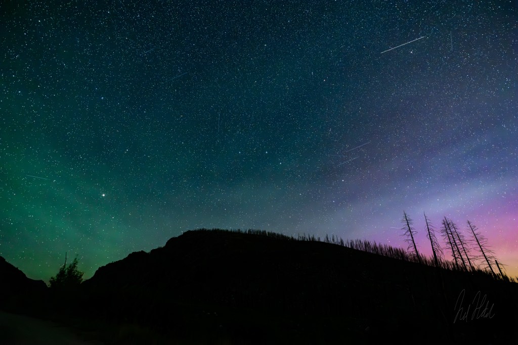
    Captured August 1st, 2024 | Bitterroot Valley, Montana

    On the same magical night I captured the Milky Way stretching overhead, I turned my camera toward the northern sky, hoping to catch more of the auroral activity forecasted during the recent solar storm. What unfolded was a surreal mix of atmospheric colors and meteor streaks that made this image feel like a cosmic painting.

    This photo was taken with my Canon R5 and RF 15–35mm f/2.8 L IS USM lens at 16mm, 13-second exposure, f/2.8, and ISO 6400. The settings were optimized to capture as much detail as possible in the sky — from dim aurora to fleeting meteors — without completely washing out the stars.

    Looking Ahead: Sharper Stars with MSM Nomad

    I’ve recently added the MSM Nomad star tracker to my toolkit — a lightweight device that counteracts Earth’s rotation, allowing for longer exposures with pinpoint stars. On future outings, I plan to use this tracker to reduce motion blur and pull in even more detail from the stars and Milky Way galactic core, while also blending exposures to retain natural foreground elements.

    Meteor Shower Highlights – Perseids?

    You’ll notice several diagonal streaks through the frame — likely part of the Perseid meteor shower, which begins ramping up in late July and peaks in mid-August. This shot, taken just after 11 PM, coincided with increased meteor activity — adding unexpected drama to an already unforgettable sky.

    Aurora in Color: Green, Yellow, Red – A Spectrum from Solar Winds

    What makes auroras so captivating is their color — and those colors aren’t random. They’re the result of energetic particles from the Sun colliding with atoms and molecules in Earth’s upper atmosphere, triggering the release of visible light in specific wavelengths.

    What caused it? A solar storm, triggered by multiple coronal mass ejections (CMEs), slammed Earth’s magnetic field, exciting particles in the upper atmosphere and igniting a G2-class geomagnetic storm (NOAA, 2024).

    During the night this photo was taken, a G2-class geomagnetic storm created ideal conditions for viewing the aurora in Montana, well south of where it’s normally visible. Here’s a breakdown of the auroral palette visible in the image:

    🟢 Green — Atomic Oxygen (Low Altitude)

    • Wavelength: ~557.7 nm (green line)
    • Altitude Range: ~100–150 km (60–93 miles)
    • Mechanism: The most common aurora color, green light is emitted when energetic electrons collide with atomic oxygen, exciting it. When the oxygen atom returns to its ground state, it emits green photons.
    • Notes: This is typically the brightest and most dominant color due to the abundance of oxygen and ideal excitation energies.

    🔴 Red — Atomic Oxygen (High Altitude)

    • Wavelength: ~630.0 nm (red line)
    • Altitude Range: ~200–500 km (124–310 miles)
    • Mechanism: Red aurora occurs higher up in the thermosphere. At these altitudes, atomic oxygen is less dense, so excited atoms can persist longer before de-exciting, resulting in red light emission.
    • Notes: Because of this long-lived excitation, red aurora often appears more diffuse and subtle, though it’s quite rare in mid-latitudes — making it a treat to catch in Montana.

    🟡 Yellow and Mixed Hues — Overlap of Emissions

    • Mechanism: Where green and red emissions overlap, the resulting colors can blend into yellow, orange, or pinkish tones, depending on intensity and viewing angle.
    • Notes: These hues are especially visible during strong solar storms when multiple altitudes of emission are active at once.

    Much fainter and more transient due to rapid de-excitation and atmospheric scattering.

    🟣 Purple and Blue — Molecular Nitrogen (N₂ and N₂⁺)

    Occur during very high-energy auroral events.

    Typically appear at lower altitudes (~80-100 km).

    Foreground Challenges: Trees in Shadow

    Foreground elements — like the stark silhouette of trees on the ridge provide grounding in an image like this. But without a moon or artificial light, exposing those elements is nearly impossible without blowing out the sky. On this night, the moon didn’t rise until 2:00 AM, meaning I was working with pure starlight. It’s a tradeoff: no moon means more visible stars and aurora, but less detail in terrestrial features.

    Looking Ahead – Better Planning, Better Shots

    While I didn’t use PhotoPills or ChatGPT to plan this shot, I’ve since started incorporating both into my workflow. Apps like PhotoPills help visualize the Milky Way’s orientation, moonrise windows, and 3D terrain, making it easier to scout ideal locations in advance. And tools like ChatGPT have been surprisingly helpful in refining those plans — offering ideas on timing, framing, and post-processing that would’ve taken hours to research on my own.

    This image may have been part luck, but future ones will lean more on intention.

    References & Resources

    Science@NASA. (2023). The Colors of the Aurora Explained.
    https://science.nasa.gov/earth-science/oceanography/living-ocean/colors-of-the-aurora/

    NOAA Space Weather Prediction Center. (2024). 30-Day Geomagnetic Forecast and Aurora Alerts.
    https://www.swpc.noaa.gov

    NASA Goddard Space Flight Center. (n.d.). What is an Aurora?
    https://www.nasa.gov/mission_pages/sunearth/aurora-overview.html

    University of Alaska Fairbanks Geophysical Institute. (n.d.). Aurora Science Explained.
    https://www.gi.alaska.edu/monitors/aurora-forecast

    National Optical Astronomy Observatory (NOAO). (n.d.). Why are auroras different colors?
    https://www.noao.edu/education/aurora.html

    American Meteor Society. (2024). Perseid Meteor Shower 2024 Peak Dates and Viewing Guide.
    https://www.amsmeteors.org

    PhotoPills. (n.d.). Plan Milky Way and Aurora Photography with PhotoPills.
    https://www.photopills.com

    Time and Date. (2024). Moonrise and Moonset Tables by Location.
    https://www.timeanddate.com/moon

    International Dark-Sky Association. (n.d.). Tips for Astrophotography in Dark Sky Areas.
    https://www.darksky.org

  • A Prairie Welcome: Maskinonge Overlook and the Gateway to Waterton Lakes

    The vast prairie greeted us as we crossed into Canada, leading us toward the towering peaks of Waterton Lakes National Park. Captured at Maskinonge Overlook with a Canon R5 at 16mm | 1/500s | f/8.0 | ISO 100.

    The Moment of Arrival

    Crossing into Canada, the landscape stretched wide before us—an expanse of golden prairie rolling toward distant mountains. At Maskinonge Overlook, just inside the entrance to Waterton Lakes National Park, we found ourselves in a transition zone where the open plains yield to the rugged peaks of the Rockies.

    The view here is one of contrast and anticipation. Behind us, the Montana plains; ahead, the rising walls of Waterton’s dramatic landscape. The sky moved swiftly, with restless clouds casting shifting shadows across the grasslands and the calm waters of Maskinonge Lake in the distance.

    With my Canon R5 and RF 15-35mm lens, set to auto, I captured the sense of space and depth that defines this place—a land that feels boundless, yet holds the promise of something towering just beyond the horizon. This photo shows the true colors of nature as minimal post processing was performed here.

    Maskinonge Overlook: Where Prairie Meets Peaks

    This overlook, situated near the park’s entrance, offers a glimpse into one of North America’s rarest landscapes. Waterton is one of the few places where the Great Plains and the Rocky Mountains collide so abruptly, creating a rich ecosystem where prairie grasses, wetlands, and alpine forests exist side by side (Parks Canada, 2023).

    The Maskinonge Wetlands, visible in the middle ground of my image, form a vital habitat for migratory birds. This shallow lake and marshy lowlands attract trumpeter swans, pelicans, and bald eagles, making it one of the best birdwatching spots in the park (Nature Conservancy Canada, 2022). The wetlands also serve as a natural filter, feeding the park’s many waterways while supporting an intricate network of plant and animal life.

    For centuries, the Maskinonge area was a seasonal gathering place for Indigenous peoples, particularly the Blackfoot Confederacy (Niitsitapi), who relied on these fertile lands for hunting, fishing, and ceremonial practices (Blackfoot Confederacy, 2021). The name “Maskinonge” itself comes from the Cree word for muskellunge, a type of large fish found in the region’s waters.

    Today, this overlook remains a place of quiet reflection, a moment of stillness before the grandeur of the mountains takes center stage.

    A Landscape Steeped in History

    Before Waterton Lakes became a national park in 1897, this land was part of a vast, untamed frontier. Indigenous communities, fur traders, and early explorers all passed through these prairies, leaving behind a history that lingers in the wind.

    In 1858, British surveyor John Palliser crossed through this very region during his exploration of the Canadian West. He noted how suddenly the land changed—how the “sea of grass” gave way to towering peaks with almost no warning. His observations would later help shape the boundaries of Waterton Lakes, ensuring that this meeting of prairie and mountains was preserved (Geological Survey of Canada, 2021).

    Chief White Calf of the Blackfoot Nation also recognized the importance of this land. In 1895, he negotiated its transfer to the Canadian government, paving the way for the establishment of Waterton Lakes National Park, though the Blackfoot people’s deep connection to the region remains to this day (Parks Canada, 2023).

    The Road to the Peaks

    From Maskinonge Overlook, the Rocky Mountains rise slowly into view, like a promise unfolding from the prairie. This transition—from wide open grasslands to sheer alpine cliffs—is what makes Waterton so distinct.

    As we left the overlook and continued into the park, the landscape seemed to shift with each passing mile. The wetlands faded into the background, replaced by ridges, valleys, and dense stands of aspen and pine. It was as if we had crossed into another world entirely.

    But the prairie, with its golden grasses and expansive skies, left its mark. Before the peaks take your breath away, the land here teaches you to pause, to take in the silence, and to appreciate the journey.

    Final Thoughts

    Maskinonge Overlook is more than just a scenic stop—it’s a place that encapsulates the spirit of Waterton. It’s a gateway where past and present, prairie and peaks, history and nature all converge.

    Here, standing between two worlds, you can feel the weight of time, the pull of the horizon, and the whispers of those who came before.

    Waterton wasn’t just a destination—it was a story, unfolding from the moment we crossed the border.

    If you would like to see more of my work as I add to my growing website, please visit my Gallery. There is lots more to come, stay tuned!

    References

    • Blackfoot Confederacy. (2021). Blackfoot history and culture. Retrieved from blackfootconfederacy.ca

    • Geological Survey of Canada. (2021). Waterton Lakes National Park: A geological history. Natural Resources Canada. Retrieved from nrcan.gc.ca

    • Nature Conservancy Canada. (2022). Protecting wetlands in Alberta. Retrieved from natureconservancy.ca

    • Parks Canada. (2023). Waterton Lakes National Park: History and Nature. Retrieved from parks.canada.ca

  • Above Waterton, Canada: A View from Bear’s Hump Overlook

    A breathtaking view of Waterton Lakes and the surrounding peaks from the Bear’s Hump Trail, captured with my Canon R5 at 16mm | 1/500s | f/8.0 | ISO 100 in the afternoon late July.

    The Climb to an Iconic View

    After our incredible journey through Yellowstone, we continued north into Canada, where we stayed in Waterton Lakes National Park, the northern extension of Glacier National Park. The two parks form the Waterton-Glacier International Peace Park, a UNESCO World Heritage Site and the first protected area dedicated to the friendship between Canada and the U.S.

    One of the park’s most iconic hikes is the Bear’s Hump Trail, a 1.8-mile out-and-back climb with a 740-foot elevation gain. While short, the ascent is relentless, leading quickly up the exposed mountainside. But with each step, the view became more dramatic—until we reached the summit and were met with an unforgettable sight.

    A View Shaped by Ice, Fire, and Wind

    From the top of Bear’s Hump, we stood above Upper Waterton Lake, the deepest lake in the Canadian Rockies, plunging nearly 500 feet (150 meters) below the surface. Formed by glaciers over 10,000 years ago, its deep blues stretched between towering ridges, carving a path southward into Glacier National Park. The striking contrast of prairie meeting mountain is unique to Waterton, a place where open grasslands abruptly collide with jagged peaks—a dramatic transition shaped by ancient glaciers and the powerful forces of the Lewis Overthrust Fault (Parks Canada, 2021).

    But if the view wasn’t humbling enough, the wind nearly knocked us off our feet. Waterton is famous for its extreme Chinook winds, which can reach hurricane-force speeds over 90 mph (145 km/h) (Lutgens & Tarbuck, 2019). These warm, dry winds sweep down the mountains, sculpting the land and making even standing still at the summit a challenge. We found ourselves bracing against gusts that made the climb feel effortless in comparison.

    Capturing the Moment

    With the wind howling around us, I quickly set up my camera—Canon R5 with an RF 15-35mm lens at 16mm—to capture the vastness of the view. I used 1/500s at f/8.0, ISO 100, ensuring clarity from the rocky foreground to the distant peaks. The fast shutter speed helped freeze the movement of the windswept vegetation, while the wide focal length captured the lake’s full grandeur as it disappeared into the mountains.

    Despite the fierce conditions, there was an undeniable beauty in the experience. The lake, the ridges, the ever-changing clouds—they all told a story of millions of years of geological transformation and the raw power of nature (Geological Survey of Canada, 2021).

    A Landscape Rich in History

    Looking down from Bear’s Hump, I couldn’t help but reflect on the significance of this place—not just in terms of scenery, but in history. For thousands of years, this land has been home to the Blackfoot Confederacy (Niitsitapi), who consider Waterton sacred and refer to it as “The Place Where the Mountains Meet the Prairie” (Blackfoot Confederacy, 2022).

    Their deep connection to the land predates national park boundaries, and their presence is still felt throughout Waterton, from preserved archeological sites to the cultural stories tied to the region. Standing there, surrounded by the forces of wind and time, it was easy to see why this landscape has long been revered.

    The Reward of Bear’s Hump

    The journey up Bear’s Hump isn’t just about the view—it’s about experiencing the elements that define Waterton. The steep climb, the roaring wind, the deep blues of the lake below—it all comes together in a way that reminds you just how alive this place is.

    As we made our way back down, the wind still howling through the ridges, I carried with me not just a photograph, but a deeper appreciation for the wild forces that shaped this land. Waterton isn’t just a place to see—it’s a place to feel. There is something humbling about standing amongst such vastness. I encourage you to add this place onto your next Glacier National Park adventure!

    If you would like to see more of my work as I add to my growing website, please visit my Gallery. There is lots more to come, stay tuned!

    References

    • Blackfoot Confederacy. (2022). Blackfoot history and culture. Retrieved from blackfootconfederacy.ca

    • Geological Survey of Canada. (2021). Waterton Lakes National Park: A geological history. Natural Resources Canada. Retrieved from nrcan.gc.ca

    • Lutgens, F., & Tarbuck, E. (2019). The Atmosphere: An Introduction to Meteorology. Pearson Education.

    • Parks Canada. (2023). Waterton Lakes National Park: History and Nature. Retrieved from parks.canada.ca

  • The Living Palette: Capturing the Colors of Grand Prismatic Spring

    grand prismatic spring Yellowstone national park
    The Grand Prismatic Spring, Yellowstone National Park. Shot with Canon R5 RF15-35mm f/2.8 L lens 1/250s | f/5.6 | ISO 100

    Some places in nature feel like they belong to another world entirely. Grand Prismatic Spring is one of those places—a surreal masterpiece where geology, biology, and light converge to create an otherworldly display of color and steam. Standing before this iconic thermal feature feeling the heat and power of nat, I felt a sense of awe not just at its beauty but at the forces of nature that have shaped it over time.

    A Vibrant History
    Grand Prismatic Spring, the largest hot spring in Yellowstone and the third largest in the world, has captivated explorers and visitors for centuries. First documented by the Hayden Geological Survey in 1871, the spring was named for its striking rainbow-like colors, which mimic the optical phenomenon of light splitting into a spectrum. But long before this scientific expedition, Indigenous peoples revered Yellowstone’s thermal features, including Grand Prismatic, as sacred spaces with medicinal properties.

    Nature’s Paintbrush
    At approximately 370 feet in diameter and over 120 feet deep, Grand Prismatic Spring dwarfs everything around it, commanding attention with its sheer scale and intense colors. The vibrant hues come from layers of heat-loving microorganisms, or thermophiles, that thrive in the extreme temperatures of the spring.

    • The Blue Center: The deep blue at the heart of the spring is the result of high temperatures that inhibit most microbial life, allowing light to scatter and intensify the blue wavelengths.
    •  The Orange and Red Rings: The outer edges teem with thermophiles that create fiery tones as they adapt to slightly cooler temperatures. These rings change with the seasons, becoming more vivid in summer.

    A Photographer’s Dream
    This photograph was taken on a warm afternoon when the golden sunlight enhanced the already vivid colors of the spring. Using a Canon R5 and an RF 15-35mm f/2.8 L lens set to 15mm, I was able to capture the full scope of the spring’s beauty. The settings—1/250 sec, f/5.6, ISO 100—helped balance the bright sky and the intricate details of the microbial mats in the foreground.

    The winding orange and red patterns in the foreground drew my eye as I composed the shot. These lines not only guide the viewer’s gaze into the heart of the spring but also tell a deeper story of the geological and biological processes at play. The ethereal steam rising from the spring, set against the lush green backdrop of the surrounding hills, felt like nature’s way of completing the palette.

    The Legacy of Discovery
    Grand Prismatic Spring isn’t just a visual marvel; it’s a testament to the dynamic forces beneath Yellowstone. The superheated water bubbling to the surface is powered by the massive Yellowstone Caldera, a supervolcano lying dormant beneath the park. This connection to Yellowstone’s volcanic past reminds us of the incredible energy and history that shape this landscape.

    As I walked away from the spring, I couldn’t help but think of the explorers who first documented it, marveling at its alien beauty. It’s a place that transcends time, a living palette that continues to inspire photographers, scientists, and visitors alike.

    If you would like to see more of my work or perhaps bring one into your home, please see my Darkroom.com Gallery

    References

    • National Park Service. “Yellowstone National Park: Grand Prismatic Spring.” nps.gov.
    • Smith, Robert B. “The Yellowstone Volcano.” Geological Society of America, 2003.
  • Chasing Light at Artist Point: A Tribute to Yellowstone’s Timeless Beauty

    Yellowstone falls viewed from artist point after sunset Yellowstone national park
    Artist Point, Yellowstone National Park. Shot after sunset. Canon R5 RF15-35mm f/2.8 L lens shot at 35mm | 1/160s | f/2.8 | ISO 800

    This photograph, taken after sunset at Artist Point in July, captures the serene yet dramatic beauty of Yellowstone’s Grand Canyon. The rugged canyon walls, glowing with warm tones, guide the eye toward the majestic Lower Falls. The vibrant post-sunset sky, with its soft pinks and oranges, contrasts against the darker shadows of the canyon, evoking a harmonious blend of power and tranquility.

    This image was shot with a Canon R5 and an RF 15-35mm f/2.8 L lens set at 35mm. The settings—1/160 sec, f/2.8, ISO 800—allowed for sharp details in the low-light conditions while preserving the natural vibrancy of the scene. The wide aperture helped isolate the intricate textures of the canyon walls and ensure clarity in the distant falls.

    This shot draws inspiration from the legendary work of Ansel Adams, who immortalized Yellowstone’s landscapes in his timeless black-and-white photography. Adams’ ability to emphasize texture, light, and shadow resonates in this image, though it leans into color to showcase the transient beauty of the moment. The post-sunset sky, alive with hues that Adams could only imply in grayscale, serves as a tribute to the dynamic range of light that modern technology allows us to capture.

    Moments like these remind us why Artist Point has been a muse for countless photographers.

    If you would like to see more of my work or perhaps bring one into your home, please see my Darkroom.com Gallery

  • Reflections and Rays: Capturing the Tetons’ Afternoon Serenity

    schwabacher landing mirror reflection of grand Tetons in afternoon with sun beaming through cloud cover
    Schwabacher Landing, Grand Teton National Park. Shot with Canon R5 | RF 15-35mm f/2.8 L lens at 16 mm | 1/500 sec | f/8.0 | ISO 100 .

    There are moments in nature where the ordinary transforms into the extraordinary, and you find yourself compelled to capture it. This photograph, taken on a tranquil afternoon July 2024 at Schwabacher Landing, was more than just another stop on our journey—it was the perfect farewell to the Grand Tetons and the culmination of an awe-inspiring adventure.

    The afternoon sun, veiled by gentle clouds, cast its rays down like a divine spotlight, illuminating the Tetons in a way that felt almost otherworldly. The sky, rich with depth and texture, mirrored itself in the calm waters below, creating a perfect symmetry that was both humbling and awe-inspiring.

    For this shot, I used a Canon R5 paired with an RF 15-35mm f/2.8 L lens. Shooting wide at 16 mm at 1/500 sec, f/8.0, and ISO 100 allowed me to balance the dynamic range of the scene while maintaining sharpness and detail throughout. The wide-angle lens perfectly framed the scene, capturing the vast expanse of the landscape and the interplay of light and shadow.

    This stop at Schwabacher Landing wasn’t just a photographic opportunity—it was a moment of reflection. As the Tetons stood tall in the distance, mirrored flawlessly in the water, I found myself pausing to take it all in. The serene beauty of this place felt like nature’s way of saying goodbye, offering one last breathtaking view before we left the park.

    Schwabacher Landing gave me more than a reflection of the Tetons—it gave me closure to a journey filled with wonder, inspiration, and the kind of beauty that stays with you long after the trip ends.

    If you would like to see more of my work or perhaps bring one into your home, please see my Darkroom.com Gallery